
Beschreibung
gefaltete Straßenkarte
östliches Ontario / Ost-Ontario
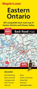
Eastern Ontario on an indexed, double-sided, GPS-compatible road map at 1:250,000 presenting the region on three panels. On one side coverage extends along the northern shore of Lake Ontario from Newcastle Village (east of Toronto and Oshawa) to Kingston and northwards to the southern access to the Algonquin Provincial Park. On the reverse two more panels extend coverage to Pembroke and Ottawa, and along the St. Lawrence River past Cornwall.
Road network indicates paved, gravel and unimproved roads. Exit numbers and motorway services are clearly marked. Railway lines and ferry connections are included and local airports are marked. A wide range of symbols indicate campsites, tourist information offices, historic sites and various places of interest, etc. The map has a 10km UTM grid.