
Beschreibung
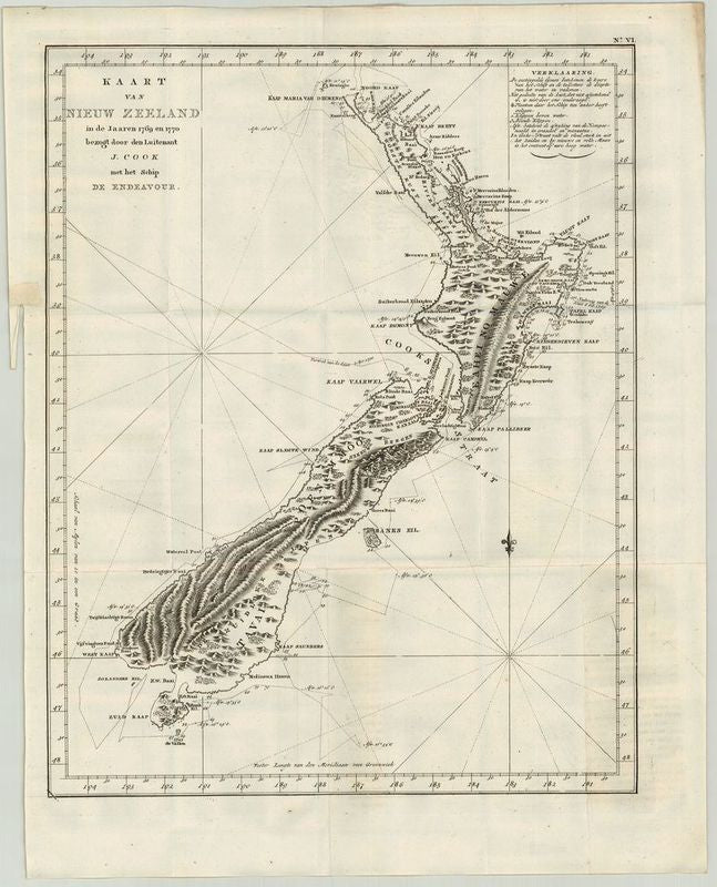
Kaart van Nieuw Zeeland in de Jaaren 1769 en 1770 bezogt door den Luitenant J.Cook
John Abraham Bayly
Karte aus der niederländischen Textausgabe. Ursprünglich erschienen war diese Karte in Hawkesworth's bedeutendem Werk "An account of the Voyages… for making Discoveries in the Southern Hemisphere", gestochen von John Abraham Bayley. Obwohl Neuseeland bereits 1642 von dem Niederländer Abel Tasman entdeckt worden ist, wurde erst durch die Umsegelung Neuseelands durch James Cook der Glaube gebrochen, die Insel sei Teil des großen südlichen Kontinents. Eine wichtige Karte der Südsee.Die Titelkartusche informiert über den Kartographen Captain James Cook, der zwischen 1769 und 1770 mit seinem Schiff Endeavour die Inseln umsegelte. Oben rechts eine sehr detaillierte Legende. Die traditionelle Windrose wird hier ersetzt durch die nach Norden gerichtete "Fleur de lys". Einige Navigationslinien schmücken den Pazifik. Der Null-Meridian ist hier bereits auf Greenwich ausgerichtet. Auf einer gestrichelten Linie kann die Umsegelung der Insel durch Cook nachvollzogen werden. Die Gebirge auf den Inseln sind schemenhaft verzeichnet - eine sehr nüchterne Darstellung des Gebietes.
unkolorierter Kupferstich
Bildmaß: 47 x 37,1 cm (Höhe x Breite)
James Cook (1728-1779) came from a modest background and after some experience at sea he entered The Royal Navy in 1754. He was involved in the 1758 survey of The St Lawrence River and Newfoundland. The Royal Navy produced extremely precise maps for the period and these proved advantageous for the British armed forces during The Seven Years War from 1756 and 1763. This was demonstrated in the successful defense of The British Isles by the Royal Navy 1759 in a naval engagement with the French. Captain Cook’s initial South Pacific exploration in 1768-1771 was to observe the transit of Venus across the Sun. This was funded by ‘The Royal Society of London for Improving Natural Knowledge’, also known as the ‘Royal Society’. Cook also had secret orders to explore any southern landmass that he might encounter.
Uncoloured copperplate engraving
Size: 47 x 37,1 cm