
Beschreibung
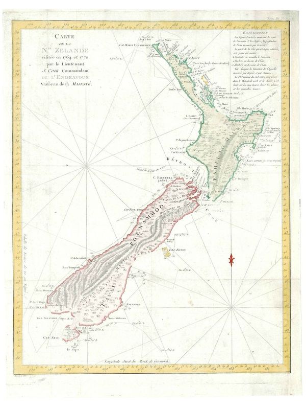
Carte de la N.le.Zelande visitée en 1769, et 1770 par le Lieutenant J.Cook.
Robert Bénard
Bei Saillant et Nyon & Panckouke,Paris.- Die Karte ist aus einer französischen Ausgabe aus Hawkesworth's bedeutender Arbeit „An Account of the Voyages… for Making Discoveries in the Southern Hemisphere“ entnommen, zuerst 1773 veröffentlicht. Der Niederländer Abel Tasman entdeckte 1642 Neuseeland, jedoch wurde erst durch die Umsegelung Neuseelands durch James Cook in den Jahren 1769 und 1770 herausgefunden, daß die Insel nicht Teil des großen südlichen Kontinents ist. Tooley, Australia pl. 21.
hochwertiger Fine Art-Print
Bildmaß: 48 x 38 cm (Höhe x Breite)
This map is from the French edition of John Hawkesworth's important work, "An Account of the Voyages for Making Discoveries in the Southern Hemisphere". Originally written by British captain and explorer James Cook and was first published in 1773. The first European discovery of New Zealand was by Dutchmen Abel Tasman in 1642. However New Zealand was first circumnavigated by Captain Cook in 1769/1770. Cook proved that the islands were not part of a great southern continent. Of note in this map is the portrayal of the Banks Peninsula as an Island and of Stewart Island as connected to the South Island. Rhumb navigational lines cross the map from two points, and a simple ‘fleur-de-lis’ indicates north on the right hand side. Robert Bénard was the engraver for the French edition of Cook's voyages between 1774-1785.
Handcoloured copperplate engraving
Size: 48 x 38 cm (Height x Width)