Der Atlantik in der Zeit um 1647 von Johannes Janssonius

OriginaldruckSKU: 2497
Keine Bewertungen

Preis:
Sonderpreis€980,00

inkl. MwSt. Versandkosten werden im Checkout berechnet.

Lagerbestand:
Auf Lager

Beschreibung

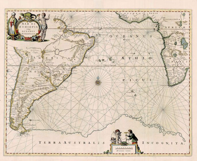
Mar di Aethiopia vulgo Oceanus Aethiopicus 1647
Johannes Janssonius

Eine wunderschöne Karte, dekoriert mit einer figürlichen Titelkartusche, ebenfalls figürlichem Meilenzeiger, Kompassrose und einer Vielzahl von Kurslinien. Die Karte zeigt fast komplett Südamerika und den südwestlichen Teil Afrikas. Feuerland ist vom Kontinent abgetrennt und ein riesiges Terra Australis Incognita erscheint im Süden der Karte. Zudem werden mehrere Inseln im Atlantik abbgebildet, eingeschlossen Dos Picos, die Falklandinseln, und Sankt Helena. Joan Janssonius (1588-1664) war der Sohn eines Arnheimer Buchhändlers und Verlegers. 1612 heiratete er die Tochter des Kartographen Jodocus Hondius und eröffnete ein eigenes Geschäft in Amsterdam. 1616 veröffentlichte er seine ersten Karten von Italien und Frankreich. In den folgenden Jahren publizierte er eine große Zahl von Karten, die Qualitativ sehr hochwertig waren. 1638 erschien der Nouvel Atlas in zwei Bänden. Zwischen 1620 und 1637 erschien der "Het Licht der Zeevaerdt", sein bedeutender Seeatlas.

handkolorierter Kupferstich
Bildmaß: 43,2 x 55,9 cm (Höhe x Breite)

A beautiful chart of the south Atlantic from 'Atlantis Majoris' decorated with a figurative title cartouche. A mileage scale is present at the bottom and the ocean is dominated by rhumb lines and a compass rose. The map shows almost all of South America and a large portion of southwestern Africa. The islands of Tierra del Fuego are separated from he vast 'Terra Australis Incognita' or 'The Unknown Land of the South' fills the bottom of the map. In addition, several islands in the Atlantic are shown including including Dos Picos, Falkland Islands, and St. Helena. Joan Janssonius (1588-1664) was the son of a bookseller and publisher from Arnhem. In 1612 he married the daughter of the cartographer Jodocus Hondius and opened his own shop in Amsterdam. In 1616 he published his first maps of Italy and France. In the following years he published a large number of high quality maps. In 1638 contributed to a complete revision of the Atlas made by Mercator-Hondius the Nouvel Atlas that was published in two volumes.

Handcoloured copperplate engraving
Size: 43,2 x 55,9 cm (Height x Width)

Das könnte Sie auch interessieren

Zuletzt angesehen