Israel und Palästina um das Jahr 1650 von Johannes Janssonius

OriginaldruckSKU: 2435
Keine Bewertungen

Preis:
Sonderpreis€798,00

inkl. MwSt. Versandkosten werden im Checkout berechnet.

Lagerbestand:
Auf Lager

Beschreibung

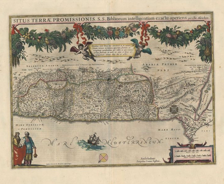
Situs Terrae Promissionis
Johannes Janssonius

Dekorative, nicht genordete Karte von Israel. Der Titel wird gerahmt. Putten tragen einen Reim, der den christlichen Gott und die Menschheit beschreibt. Unten links Figuren der christlichen Liturgie. Auf dem Mittelmeer wird ein Segelschiff von einem Seeungeheuer angegriffen. Die Karte verzeichnet biblische Orte, deren Lage unsicher ist.

Grenzkolorierter Kupferstich
Bildmaß: 37,5 x 49,7 cm (Höhe x Breite)


This is a decorative nore easterly orientated map of Israel. The central title is framed with cherubs and has a rhyme that describes the Christian God and humanity. On the bottom left are figures of the Christian liturgy. In the middle of the Mediterranean a sailing ship is attacked by a sea monster. The map show the passage of the Israeilists from Egypt across the desert and other biblical events. Johannes Janssonius (1588-1664) was the son of a bookseller and publisher from Arnhem. In 1612 he married the daughter of the cartographer Jodocus Hondius and opened his own shop in Amsterdam. In 1616 he published his first maps of Italy and France. In 1638 he contributed to a complete revision of the Atlas made by Mercator-Hondius the Nouvel Atlas which was published in two volumes.

Handcoloured copperplate engraving
Size: 37,5 x 49,7 cm (Height x Width)

Das könnte Sie auch interessieren

Zuletzt angesehen